Leveraging New Transit For Better Communities
In spite of a general understanding that land use and transit need to go hand in hand and the inclusion of the three letters "TOD" into the everyday lexicon of planners, development (D) that is actually oriented (O) on transit (T) remains scarce. All too often, the T and the D barely coexist, let alone provide mutual synergy. And so the promise of community improvement which is leveraged by transit remains often unfulfilled as well.
 |
| Above the session description from the Conference program:Presentations → |
When the annual national "Partners for Smart Growth Conference" came to Baltimore this year, it was tempting to use the state's two current large New Starts projects, the Red Line and the Purple Line, to highlight the transit and land use linkage and demonstrate what steps can be taken to make communities better alongside with the design of the rail projects and fueled by the investment in transit.
As one of the presenters, I share here my presentation slides and the essence of my talk which was embedded in presentations about the Purple Line, Affordable Housing (an important use along transit) and the Opportunity Collaborative (a regional look at transit, housing and jobs). My presentation focuses on the Red Line, the New Starts requirements to consider land use during the planning process, what tools were developed to collaborate with the jurisdictions having authority over land use, and considerations of equity. I use two station areas as examples of community based planning concepts and discuss ways how those plans could be implemented and how implementation schedules have to be coordinated between transit and development. (The presentations of the other panelists can be obtained by clicking on the link "Presentations" above in the caption under the session program).
Slide 1

After Ting Ma’s presentation of the Purple Line I will speak about Maryland’s second large New Starts project, the Baltimore Red Line.
My approach will be less data based and focus more on what has been done to involve communities, address equity and how to make land use part of the transit planning process
At a time when both New Starts projects may still be cancelled by the new Governor of Maryland, this process is far from complete but a few lessons can be learned already.
Slide 2
At a smart growth conference I don’t need to explain that today it isn't sufficient anymore to just build a transit line and then operate it. Land use, housing, environment, and transportation need to be fully integrated to achieve economic development and environmental justice, in other words: Sustainable communities, .

On the federal level DOT, EPA and HUD have formed a Partnership for Sustainable Communities. The State of Maryland uses the same term for a number of incentive programs, one of them Transit Oriented Development (TOD).
The feds get it, the state gets it, how about the local government?
Slide 3
What is so hard about connecting land use and transportation?
Good transit plus people using land the right way makes for good communities. Looks simple enough!

The difficulty becomes clear when one considers who plans transit and who plans land use.
Those entities usually don’t talk much with each other. Land use and transit happen in different universes, really, and in Maryland those universes are the State (for transit) and local government (for land use).
Those entities usually don’t talk much with each other. Land use and transit happen in different universes, really, and in Maryland those universes are the State (for transit) and local government (for land use).
Slide 4

For federal New Starts projects like the Purple and Red Lines, economic development, environment, and land use are part of the project evaluation.
In fact, land use and environment related matters weigh in at 50% of the evaluation!
Slide 5
Many of you probably remember the time when transit planning
meant essentially dropping projects into
meant essentially dropping projects into

Baltimore’s existing Central Light Rail line, built in the early 1990’s is such an example.
Although it successfully linked Oriole Park to transit, it otherwise never initiated a comprehensive look at zoning or never involved communities in anything that went beyond the design of the line itself and its stations.
Although it successfully linked Oriole Park to transit, it otherwise never initiated a comprehensive look at zoning or never involved communities in anything that went beyond the design of the line itself and its stations.
.JPG)
Slide 6
By contrast, the Red Line, which started planning about 12 years ago, ran a much more comprehensive and community based approach. Before talking about that approach let me introduce the project.
Slide 7
Here is a brief overview of the
Red Line:
Red Line:

The Red Line is part of an ambitious comprehensive rail plan of which it is the third piece and a critical east-west line connecting to both of the two existing rail lines, the already mentioned Central Light Rail line (blue) and the existing Metro subway (green).
I believe that the third rail line will turn the two existing lines (which so far "fly in loose formation") into a connected rail system. In other words, benefits will extend far beyond the Red Line's own corridor and include all other rail destinations such as the Johns Hopkins Hospital, the airport, the Hunt Valley job center, or the main Amtrak station.
I believe that the third rail line will turn the two existing lines (which so far "fly in loose formation") into a connected rail system. In other words, benefits will extend far beyond the Red Line's own corridor and include all other rail destinations such as the Johns Hopkins Hospital, the airport, the Hunt Valley job center, or the main Amtrak station.
Slide 8

The Red Line, here shown in the selected alignment, is over 14 miles long and has 19 stations, 5 of which are underground, i.e. this light rail runs like a metro through downtown and historic Fells Point. The line is expected to have 55,000 riders and a cost of $ 2.9 billion thanks to the large tunnel segments which increase travel speed, ridership and cost.
Slide 9
Like the Purple Line corridor, the corridor is defined by its influence zone, not just the walk circles around stations.

When selecting a new transit line alignment a happy medium has to be found between already transit supportive land use and the potential for future development.
The corridor maps show existing residential and employment densities. The Red Line touches on a number of dark-colored dense areas in the center of Baltimore. Then, density peters out from the center. Nothing particularly out of the ordinary so far.
Slide 10

This slide shows already planned development. It seems pretty evenly spread along the corridor. Of course, these planned future developments could either be transit adjacent development or they could be true transit oriented development, a critical difference!
To be actually transit oriented each of these developments would need to have a transit supportive use and a configuration that takes maximum advantage of transit through its lay-out, density, orientation, circulation etc.
A lesson we learned is that during planning of a line, developers don’t like to design as if it is certain the line will come. Instead they tend to hedge against the case that it wouldn’t. This can be self-defeating, though. If many developments truly depend on getting the line actually built, developers have skin in the game and will collectively see to it that the transit will be realized, increasing the political pressure, the project ranking and making it less likely that the line can be scrapped for political reasons.
How important that is, we see now after MD has a new Governor. Clearly, the more development and community investments resulting from the planning process alone, the harder it is to kill such a transit project!
Slide 11

Many of these real projects shown here are in various states of planning or realization. Some are merely transit adjacent, i.e. they would look exactly the same with or without the Red Line, others are truly relying on the Red Line to become reality.
Slide 12
There is at least one other thing to consider: Equity!

When we look at income, vacant units, or other measures of wealth, the Red Line is very much a system that serves the proverbial "two cities."
One city of disinvestment and poverty, where services are scarce and people depend on transit to get around lies directly west of downtown. A city that is booming, affluent and largely car-oriented is located at the eastern waterfront. Additionally, and a newer phenomenon, is the rapidly growing downtown area in the middle in which thousands of new apartments are built in old office spaces. All three parts of the city clamor for better transit, for different reasons.
I will describe one example station area on the west and one on the east and talk about community aspirations and the possible inclusion of affordable housing.
Slide 13

Two things were done for the Red Line that go above and beyond what is required by the New Starts or NEPA regulations: First, the Community Compact, an initiative by the City of Baltimore started in the early years of the project under then mayor Sheila Dixon.
Second, the community based Station Area Advisory Committee (SAAC) process initiated by the transit agency MTA, delivering on one of the commitments of the Compact.
I will elaborate a bit on both approaches, and how they address equity.
Slide 14
The Compact committed to community benefits and was underwritten by over 60 different agencies, non-profits, organizations, communities and other stakeholders.

The Compact addresses
- · Sustainability (Making the Red Line Green)
- · Workforce Development (Putting Baltimore to Work)
- · and Community Centered Station Area Design

The Compact very specifically commits to dealing with land use and development including the following specific steps:
- · Baltimore City will develop and fund a Red Line neighborhood investment strategy
- · Work with local foundations and other partners to create a public-private entity similar to Atlanta’s “BeltLine Partnership”
- · Begin now to assemble land through the City’s Land Bank,
- · Implement non-traditional funding strategies for public/private partnerships
- · Work with station area communities to seek grant opportunities for State, federal and private funding sources
Slide 16

As noted, the commitment to community based Station Area Planning was fulfilled through the Station Area Committees:
16 communities met over 18 months to first develop station area visions and then concept plans based on those visions.
We will use two station areas as examples, one on the west side and one on the east side of downtown.

Slide 17
One of the dis-invested areas without a market is West Baltimore, which happens to also be Baltimore's transit gateway to Washington, DC.
The West Baltimore community, once thriving and a model of beautiful brownstone architecture and urban squares, was ransacked by urban expressway construction, de-industrialization, and urban flight.
As a result the existing commuter rail station, which is proposed to become an intermodal transfer station, sits in a big "hole in the doughnut." Plenty of land to re-develop and the promise of a red hot market in Washington DC, only 35 miles away, and which just added something like 40k residents in 10 years!
Slide 18

During the planning process, the West Baltimore community had no trouble filling the hole in the doughnut with suggested new uses and the kind of services currently lacking in the community. The resulting concept plan was adopted by the city planning commission as an official strategic plan.
However, drawing a vision and seeing actual investment are two different things entirely. With a plan in place, the question now is this: How can the community get what they expressed in this vision? Who would have to come to the table to make it happen? Who would set up and guide “the deals,” what governance would allow the community to remain a “player” and what scale is needed to “create” a market?

The simple presence of a worked-out plan has yielded one success already: City TIGER funds were used to level two blocks of abandoned expressway concrete to create regular level urban blocks initially used for more commuter parking spaces desired by the community to get commuters out of neighborhood streets.
More parking wouldn’t really be a reason to celebrate were it not for the fact that these lots were designed for future TOD development. They represent city-owned bargaining chips for future public-private partnerships (P3). Some future deal needs to link up the lots, the privately owned industrial sites and the transit provider (MTA) to enter into such a public-private partnership and provide enough scale for development that a market could arise.
With these important ingredients in place, other steps like land-banking, land disposition, and lot consolidation, incentives such as a TIF district, the creation of a development ombudsman, or improvements to surrounding areas still wait for a champion to spearhead and coordinate these steps. This is the issue of governance.
Slide 20
The other example is located on the east side, just north of the waterfront areas that are red hot markets. As illustrated recently by the British magazine the Economist, immigrants have transformed the communities of Highlandtown and Greektown a second time in their history and made Eastern Ave once again into a vital “main street”. (video)

The proposed Highlandtown station, though, sits once again in some kind of hole in the doughnut, separating Highlandtown and Greektown.
Here, too the Red Line investment could be the catalyst to set off the right land use that would connect the two communities and make the rail line a connector instead of a divider.
With two communities well on the mend, the set of actions needed is different than in West Baltimore. While here a market may be present, land disposition and deal making are still needed to achieve the desired outcomes.
Slide 21
The slide shows on the left today’s major property in the station area, the former Crown Cork and Seal factory; not as desolate as it looks, it is actually a haven for small business and artists. The community developed vision, nevertheless, looks quite different than today’s condition.

Once again, what will it take to make this happen? Here some progress has been made as well:
-Enterprise Community Partners gave money to the owner of Crown Cork & Seal to create a masterplan for his extensive facility
-The city is doing an access study to resolve some of the access problems resulting from the many railroad lines
- A local CDC is leading and coordinating various efforts
Still, there is need for somebody who pays attention to these matters every day, coordinates, pushes, pulls and makes things happen.
Still, there is need for somebody who pays attention to these matters every day, coordinates, pushes, pulls and makes things happen.

Slide 22
How much time is of the essence for these two examples as well as all the other station areas becomes clear when one defines as the goal that these communities should look different by the time the first train stops in those stations.
How much time is of the essence for these two examples as well as all the other station areas becomes clear when one defines as the goal that these communities should look different by the time the first train stops in those stations.
Let me show how the schedule for those community-based planning and development efforts need to be timed so that they are synchronized with the construction of the transit line.
Slide 23

Today, designers and engineers for the transit line are completing bid packages for the design-bid-build and for the P3 segments of the project so that construction can begin later this year and in early 2016. Revenue service is planned to begin in late 2021 or early 2022.
For the already noted Compact promises like a
·
- Red Line neighborhood investment strategy
- · A public-private entity similar to Atlanta’s “BeltLine Partnership”
- · A City Land Bank for targeted acquisition strategies,
- · non-traditional funding strategies in public/private partnerships and
- · grant opportunities for State, federal and private funding sources
it is high time for them to take shape.
For any of this to actually happen, somebody has to pay attention to TOD and station area development every day and needs to report ideally directly to the Mayor.
Slide 24

Should the Red Line start construction this year or next, we would need every minute to bring the development piece into a position where it can catch up with planning and have a chance to be completed at least in part by the time the line opens.
Slide 25
Organizational structures to underpin such a transit oriented development focus could include:
· A Stakeholder Coalition like
it it has been instituted for the
Purple Line
it it has been instituted for the
Purple Line
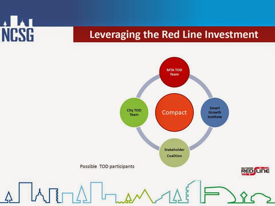
· A city led TOD Working Group
·
A TOD czar with the support of a TOD cabinet as was instituted by the mayor of Los Angeles
A TOD czar with the support of a TOD cabinet as was instituted by the mayor of Los Angeles
In closing and to summarize:
To make transit-oriented development happen it takes a willing transit agency, willing developers, cooperative communities and willing local government plus a suitable governance structure to shepherd development along.
To make transit-oriented development happen it takes a willing transit agency, willing developers, cooperative communities and willing local government plus a suitable governance structure to shepherd development along.
Ilana’s and Lisa will give additional insight into what activities are underway, possible or recommended and how they could happen.
End of presentation
Postscript
The breadth of presentations allowed the distillation of a few common threads that spread like umbrellas across the myriad of issues. One of those umbrellas is transportation and transit. With good transit, equity can be addressed through better access and lower cost; transit can increase resilience and sustainability; transit can help create memorable urban spaces and transit can make a city more livable. Any one of those benefits, however, will only come about when land use and transportation are truly integrated, when development is synergistic and transit is more than a mere bystander.
Klaus Philipsen, FAIA
edited by Ben Groff
Related articles on this Blog:
Transit, Losing by not Investing
The Transit and Development Tango
What Makes a Good Transit System?
A City for People instead of Cars
External Links
New Partners Conference Presentations


.JPG)


Post a Comment